Chuuk International Airport | Kosrae International Airport | Fais | Houk (Pulusuk) | Mortlock Islands (Ta) | Mwoakilloa Atoll | Onoun (Ulul) | Pingelap Atoll | Pohnpei International Airport | Sapwuahfik Atoll | Ulithi | Woleai | Yap International Airport
Ulithi Civil Airfield is located in Yap State on Falalop Island on the northeast side of Ulithi Atoll, roughly 120 miles (194 km) east of Yap International Airport. It is currently served by Pacific Missionary Aviation. In order to utilize the airstrip, operators must apply for the appropriate flight permits with the F.S.M. Division of Civil Aviation. The airfield is unattended.
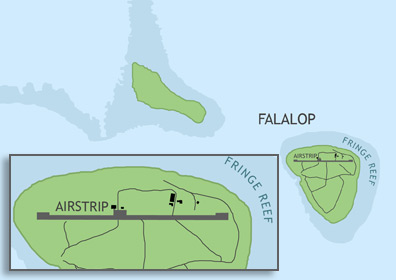
ABOUT ULITHI ATOLL & FALALOP ISLAND
Ulithi Atoll consists of 40 islands with a total land area of 1.7 square miles, surrounding one of the largest lagoons in the world. The four inhabited islands of Falalop, Asor, Mogmog, and Fedarai support about 770 people, who speak the Ulithian language. The atoll is known for its good fishing and SCUBA diving and played a significant part in the U.S. Navy's Pacific Operations during WWII. Falalop Island is set apart from the rest of the atoll by a distance of just under a mile. The island is 0.68 miles at its widest point and 0.73 miles long.
BASIC AIRFIELD INFORMATION
| IATA Code: | ULI |
| FAA Identifier: | TT02 |
| Lat/Long: | 10-01-00.0000N / 139-48-00.0000E 10-01.000000N / 139-48.000000E 10.0166667 / 139.8000000 (estimated) |
| Elevation: | 6 feet |
| Variation: | 02E (1985) |
| From Population Center: | 0.3 miles / 0.48 km N of primary settlements on FALALOP ISLAND, ULITHI ATOLL |
| Time Zone: | UTC +10 (year round; does not observe DST) |
AIRFIELD OPERATIONS
| Airport use: | Open to the public, PPR FOR LANDING TO BE FILED 48 HRS IN ADVANCE WITH FSM SECRETARY OF TRANSPORTATION, COMMUNICATIONS & INFRASTRUCTURE: DIVISION OF CIVIL AVIATION. |
| Activation Date: | 05/1977 |
| Sectional Chart: | GNC 13 |
| Control Tower: | no |
| Lights: | no |
| Segmented Circle: | no |
AIRFIELD COMMUNICATIONS
| CTAF: | 123.6 (COMS provided by Yap Radio) |
AIRFIELD SERVICES
| Oil Available: | yes |
AIRSTRIP INFORMATION
| Dimensions: | 3000 x 75 ft / 914 x 23 m |
| Surface: | concrete, in fair condition |
| Lights: | no |
| Latitude: | 10° 1'13.39"N (estimated) |
| Longitude: | 139°47'20.32"E (estimated) |
| Elevation: | 6 feet |
| Runway Heading: | 090 |
| Markings: | no |