Chuuk International Airport | Kosrae International Airport | Fais | Houk (Pulusuk) | Mortlock Islands (Ta) | Mwoakilloa Atoll | Onoun (Ulul) | Pingelap Atoll | Pohnpei International Airport | Sapwuahfik Atoll | Ulithi | Woleai | Yap International Airport
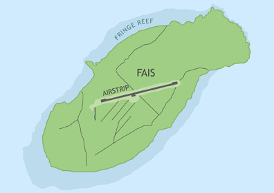
Fais Civil Airfield is located in Yap State on Fais Island, roughly 166 miles (268 km) east of Yap International Airport and 53 miles (85 km) east of Ulithi Atoll. It is currently served by Pacific Missionary Aviation. In order to utilize the airstrip, operators must apply for the appropriate flight permits with the F.S.M. Division of Civil Aviation. The airfield is unattended.
ABOUT FAIS ISLAND
Fais is a raised coral island about 1.67 miles long and 0.7 miles wide surrounded by a small fringing reef. The island has a maximum elevation of 60 feet and a total land area of one square mile, supporting a population of about 220 people. Most of the inhabitants live on the southern side of the island near the coast. According to the island's origin myth, one of three brothers snagged Fais with a hook while fishing and dragged it to the surface of the ocean.
BASIC AIRFIELD INFORMATION
| Lat/Long: | 9°45'46.50"N / 140°31'4.69"E (estimated) |
| From Population Center: | 0.45 miles / 0.73 km NE of primary settlements on FAIS ISLAND |
| Time Zone: | UTC +10 (year round; does not observe DST) |
AIRFIELD OPERATIONS
| Airport Use: | Open to the public, PPR FOR LANDING TO BE FILED 48 HRS IN ADVANCE WITH FSM SECRETARY OF TRANSPORTATION, COMMUNICATIONS & INFRASTRUCTURE: DIVISION OF CIVIL AVIATION. |
| Control Tower: | no |
| Lights: | no |
| Beacon: | no |
AIRFIELD COMMUNICATIONS
| CTAF: | 123.6 (COMS provided by Yap Radio) |
AIRFIELD SERVICES
| Fuel Available: | no |
AIRSTRIP INFORMATION
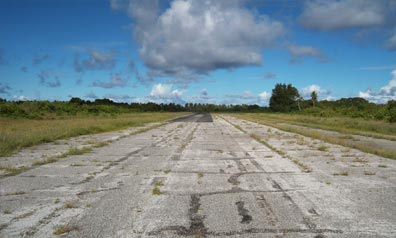
| Dimensions: | 3000 x 75 ft / 914 x 23 m |
| Surface: | chip seal, in poor condition, severe cracks, lose debris, last surface work completed in 1992 |
| Lights: | no |
| Latitude: | 9°45'46.50"N (estimated) |
| Longitude: | 140°31'4.69"E (estimated) |
| Runway Heading: | 076 |
| Markings: | no |