Chuuk International Airport | Kosrae International Airport | Fais | Houk (Pulusuk) | Mortlock Islands (Ta) | Mwoakilloa Atoll | Onoun (Ulul) | Pingelap Atoll | Pohnpei International Airport | Sapwuahfik Atoll | Ulithi | Woleai | Yap International Airport
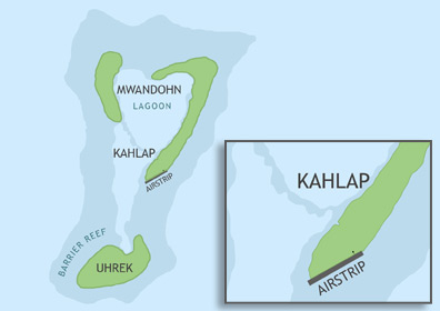
Mwoakilloa Civil Airfield is located in Pohnpei State on the southeast edge of Kahlap Island, the largest of three islands that compose Mwoakilloa Atoll, roughly 95 nautical miles (153 km) east of Pohnpei Island and 84 nautical miles (113 km) northwest of Pingelap Atoll. In order to utilize the airstrip, operators must apply for the appropriate flight permits with the F.S.M. Division of Civil Aviation. Once approval has been granted, the operator can contact the Pohnpei Port Authority Airport Manager to make arrangements for on-call personnel to be present at the airfield.
ABOUT MWOAKILLOA ATOLL
The atoll of Mwoakilloa (formerly known as Mokil) is 2.8 miles long and 1.7 miles at its widest point. Only Kahlap is inhabited with most of the roughly 150 inhabitants living along the lagoon side of the island. All three islands have a cumulative land area of 0.8 square miles. The local language is Mwoakillese and is closely related to the Pohnpeian language, though many inhabitants are also fluent in English.
BASIC AIRFIELD INFORMATION
| Lat/Long: | 6°40'44.77"N / 159°45'38.82"E (estimated) |
| Elevation: | 8 ft |
| From Population Center: | 1.1 miles / 1.8 km S of primary settlements on KAHLAP ISLAND, MWOAKILLOA ATOLL |
| Time Zone: | UTC +11 (year round; does not observe DST) |
AIRFIELD OPERATIONS
| Airport Use: | Open to the public, PPR FOR LANDING TO BE FILED 48 HRS IN ADVANCE WITH FSM SECRETARY OF TRANSPORTATION, COMMUNICATIONS & INFRASTRUCTURE: DIVISION OF CIVIL AVIATION. |
| Control Tower: | no |
| Lights: | no |
| Beacon: | no |
AIRFIELD COMMUNICATIONS
| CTAF: | 123.6 (COMS provided by Pohnpei Radio) |
AIRFIELD SERVICES
| Fuel Available: | no |
AIRSTRIP INFORMATION
| Dimensions: | 1200 x 100 ft / 366 x 30 m |
| Surface: | concrete, in fair condition, some significant surface cracks |
| Lights: | no |
| Latitude: | 6°40'41.52"N (estimated) |
| Longitude: | 159°45'35.32"E (estimated) |
| Elevation: | 8 ft |
| Runway heading: | 060 |
| Markings: | yes |