Chuuk International Airport | Kosrae International Airport | Fais | Houk (Pulusuk) | Mortlock Islands (Ta) | Mwoakilloa Atoll | Onoun (Ulul) | Pingelap Atoll | Pohnpei International Airport | Sapwuahfik Atoll | Ulithi | Woleai | Yap International Airport
Houk Civil Airfield is located in Chuuk State on Houk Island, also known as Pulusuk, roughly 183 miles (294 km) southwest of Chuuk International Airport and 135 miles (217 km) south of Namonuito Atoll. It is currently served by Caroline Islands Air. In order to utilize the airstrip, operators must apply for the appropriate flight permits with the F.S.M. Division of Civil Aviation. Once approval has been granted, the operator can contact the Chuuk Port Authority Airport Manager to make arrangements for on-call personnel to be present at the airfield.
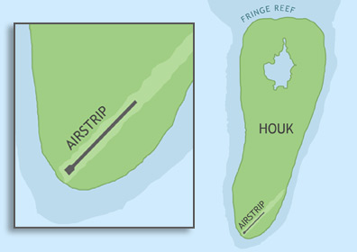
ABOUT HOUK ISLAND
Houk Island, or Pulusuk, lies at the end of a 35 mile-long submerged atoll called Manila Reef and belongs to the Pattiw island group. The island is shaped like an inverted pear, 2 miles long and 0.6 miles wide. Most of Houk's inhabitants live in the middle of the island around the western coast.
BASIC AIRFIELD INFORMATION
| Lat/Long: | 6°40'29.25"N / 149°17'55.29"E (estimated) |
| From Population Center: | 0.8 miles / 1.4 km S of primary settlements on HOUK ISLAND |
| Time Zone: | UTC +10 (year round; does not observe DST) |
AIRFIELD OPERATIONS
| Airport Use: | Open to the public, PPR FOR LANDING TO BE FILED 48 HRS IN ADVANCE WITH FSM SECRETARY OF TRANSPORTATION, COMMUNICATIONS & INFRASTRUCTURE: DIVISION OF CIVIL AVIATION. |
| Control Tower: | no |
| Lights: | no |
| Beacon: | no |
AIRFIELD COMMUNICATIONS
| CTAF: | 123.6 (COMS provided by Truk Radio) |
AIRFIELD SERVICES
| Fuel available: | no |
AIRSTRIP INFORMATION
| Dimensions: | 1350 x 50 ft / 411 x 15 m |
| Surface: | concrete, in fair condition, some significant surface cracks |
| Lights: | no |
| Latitude: | 6°40'29.25"N (estimated) |
| Longitude: | 149°17'55.29"E (estimated) |
| Runway heading: | 044 |
| Markings: | no |