Chuuk International Airport | Kosrae International Airport | Fais | Houk (Pulusuk) | Mortlock Islands (Ta) | Mwoakilloa Atoll | Onoun (Ulul) | Pingelap Atoll | Pohnpei International Airport | Sapwuahfik Atoll | Ulithi | Woleai | Yap International Airport
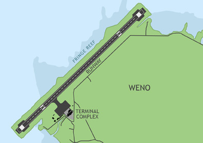
Chuuk International Airport (TKK) is located on Weno Island in the middle of Chuuk Lagoon. The airport receives regular commercial flights from Guam and Honolulu (via Pohnpei). Caroline Islands Air makes periodic flights the outer island airfields of Houk (Pulusuk), Ta (Mortlock Islands), and Onoun.
ABOUT CHUUK
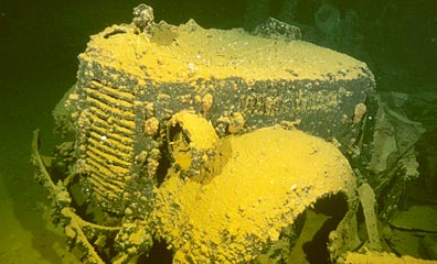
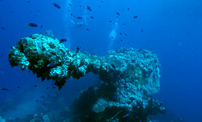
Chuuk, formerly known as Truk, is a large collection of relatively small islands that forms the most populous state in the F.S.M. At Chuuk's center are the mountainous islands inside vast Chuuk Lagoon. Beyond this are several major atoll groups, including the Mortlock Islands, Hall Islands, Namonuito Atoll, and the Pattiw group. Chuuk is the most famous of Micronesia's islands due to the part it played in WWII, when a large part of the Japanese naval fleet was sunk in the lagoon by the U.S. bombing campaign dubbed Operation Hailstone. It has since become the No. 1 wreck-diving destination in the world. Twelve warships and 32 merchant ships lie on the bottom, now encrusted with thriving coral growth and hosting a myriad of sea creatures.
Chuuk's outer atolls--particularly Puluwat and Pollap--are also special, known for producing masters in the art of oceanic navigation.
BASIC INFORMATION
| FAA Identifier: | TKK |
| Lat/Long: | 07-27-42.8130N / 151-50-34.8770E 07-27.713550N / 151-50.581283E 7.4618925 / 151.8430214 (estimated) |
| Elevation: | 10 ft. / 3.0 m (surveyed) |
| Variation: | 05E (1990) |
| From Population Center: | 0.66 miles / 1 km NW of WENO ISLAND |
| Time Zone: | UTC +10 (year round; does not observe DST) |
AIRPORT OPERATIONS
| Airport Use: | Open to the public, PPR FOR LANDING TO BE FILED 48 HRS IN ADVANCE WITH FSM SECRETARY OF TRANSPORTATION, COMMUNICATIONS & INFRASTRUCTURE DIVISION OF CIVIL AVIATION. |
| Activation Date: | 06/1964 |
| Sectional Chart: | GNC 7 |
| Control Tower: | no |
| ARTCC: | HONOLULU CONTROL FACILITY CENTER |
| FSS: | HONOLULU FLIGHT SERVICE STATION |
| NOTAMs Facility: | PTKK (NOTAM-D service available) |
| Wind Indicator: | lighted |
| Segmented Circle: | yes |
| Lights: | RDO-CTL ACTVT MIRL; VASIS & REILS RWY 04/22 - 123.6. |
| Beacon: | white-green (lighted land airport) |
| International Operations: | international airport of entry |
AIRPORT COMMUNICATIONS
| CTAF: | 123.6 (COMS provided by Truk Radio) |
AIRPORT SERVICES
Fuel Available: |
100LL JET-A1+ TRANSIENT AIRCRAFT MUST MAKE PRIOR ARRANGEMENTS FOR FUEL BY CALLING 691.370.2477. |
| Airframe Service: | no |
| Powerplant Service: | no |
| Bottled Oxygen: | no |
| Bulk Oxygen: | no |
RUNWAY 4 / 22 INFORMATION
| Dimensions: | 6006 x 150 ft. / 1831 x 46 m | |||||
| Surface: | asphalt/grooved, in good condition | |||||
| Weight Bearing Capacity: |
|
|||||
| Runway Edge Lights: | medium intensity | |||||
| Runway Edge Markings: | & RWY 22 NSTD DISTANCE REMAINING MKRS BOTH SIDES OF RY. | |||||
| RUNWAY 4 | RUNWAY 22 | |||||
| Latitude: | 07-27.368600N | 07-28.058517N | ||||
| Longitude: | 151-50.223433E | 151-50.939117E | ||||
| Elevation: | 10.2 ft. | 9.8 ft. | ||||
| Traffic Pattern: | left | right | ||||
| Runway Heading: | 041 magnetic, 046 true | 221 magnetic, 226 true | ||||
| Markings: | nonprecision, in good condition | nonprecision, in good condition | ||||
| Visual Slope Indicator: | 4-light PAPI on left (3.00 degrees glide path) | 4-light PAPI on left (3.00 degrees glide path) | ||||
| Runway End Identifier Lights: | yes | yes | ||||
| Touchdown Point: | yes, no lights | yes, no lights | ||||
| Obstructions: | 3 ft. berm, 1 ft. from runway & RY 22 APCH RATIO 50:1 TO DSPLCD THR. |
3 ft. berm, 1 ft. from runway |