Chuuk International Airport | Kosrae International Airport | Fais | Houk (Pulusuk) | Mortlock Islands (Ta) | Mwoakilloa Atoll | Onoun (Ulul) | Pingelap Atoll | Pohnpei International Airport | Sapwuahfik Atoll | Ulithi | Woleai | Yap International Airport
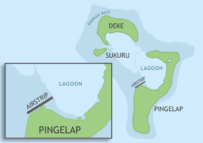
Pingelap Civil Airfield is located in Pohnpei State on the west coast of the largest and southernmost of the three islands that compose Pingelap Atoll, roughly 154 nautical miles (285 km) west of Pohnpei Island. In order to utilize the airstrip, operators must apply for the appropriate flight permits with the F.S.M. Division of Civil Aviation. Once approval has been granted, the operator can contact the Pohnpei Port Authority Airport Manager to make arrangements for on-call personnel to be present at the airfield.
ABOUT PINGELAP ATOLL
Pingelap Atoll is 2.6 miles long and 1.6 miles at its widest point. Only the largest island is inhabited with roughly 250 residents living mostly near the airfield on the west side of the island. The three islands have a cumulative land area of 1.1 square miles. The local language is Pingelapese, though English is also spoken. Pingelap is famous among geneticists around the world because of the high occurrence of achromatopsia (a type of color-blindness). Perpetuated by a small gene pool and rapid population growth, nearly 10% of the current population suffers from the condition. Neurologist Oliver Sacks' 1997 book, The Island of the Colorblind, was written about the atoll.

BASIC AIRFIELD INFORMATION
| Lat/Long: | 6°12'40.66"N / 160°42'16.02"E (estimated) |
| Elevation: | 8 ft |
| From population center: | 328 ft / 100 m N of primary settlements on PINGELAP ISLAND, PINGELAP ATOLL |
| Time zone: | UTC +11 (year round; does not observe DST) |
AIRFIELD OPERATIONS
| Airport use: | Open to the public, PPR FOR LANDING TO BE FILED 48 HRS IN ADVANCE WITH FSM SECRETARY OF TRANSPORTATION, COMMUNICATIONS & INFRASTRUCTURE: DIVISION OF CIVIL AVIATION. |
| Control tower: | no |
| Lights: | no |
| Beacon: | no |
AIRFIELD COMMUNICATIONS
| CTAF: | 123.6 (COMS provided by Pohnpei Radio) |
AIRFIELD SERVICES
| Fuel available: | no |
RUNWAY INFORMATION
| Dimensions: | 1200 x 100 ft / 366 x 30 m |
| Surface: | concrete, in fair condition, deteriorated paving in some places, eroded fringe |
| Lights: | no |
| Latitude: | 6°12'40.66"N (estimated) |
| Longitude: | 160°42'16.02"E (estimated) |
| Elevation: | 8 ft |
| Runway heading: | 057 |
| Markings: | yes, faded |