Chuuk International Airport | Kosrae International Airport | Fais | Houk (Pulusuk) | Mortlock Islands (Ta) | Mwoakilloa Atoll | Onoun (Ulul) | Pingelap Atoll | Pohnpei International Airport | Sapwuahfik Atoll | Ulithi | Woleai | Yap International Airport
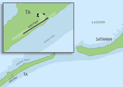
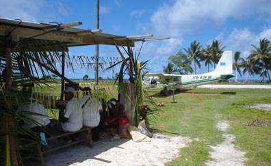
Mortlock Islands Civil Airfield is located in Chuuk State on Ta Island, the southern-most of the islands of Satawan Atoll, roughly 194 miles (312 km) southeast of Chuuk International Airport. It is currently served by Caroline Islands Air. In order to utilize the airstrip, operators must apply for the appropriate flight permits with the F.S.M. Division of Civil Aviation. Once approval has been granted, the operator can contact the Chuuk Port Authority Airport Manager to make arrangements for on-call personnel to be present at the airfield.
ABOUT SATAWAN ATOLL & TA ISLAND
Satawan Atoll consists of 4 primary islands--of which the largest are Satawan and Ta on the southeast side--and a scattering of smaller islets surrounding a large lagoon. Lukunor and Etal Atolls lie to the north. Satawan has a total land area of 1.8 square miles and supports 2,935 people, who speak the Mortlockese language (closely related to Chuukese). The majority of the inhabitants live on Satawan Island, a short walk at low tide from Ta.
BASIC AIRFIELD INFORMATION
| Lat/Long: | 5°18'57.05"N / 153°42'28.27"E (estimated) |
| From Population Center: | 1.5 miles / 2.4 km SW of primary settlements on SATAWAN ISLAND, SATAWAN ATOLL |
| Time Zone: | UTC +10 (year round; does not observe DST) |
AIRFIELD OPERATIONS
| Airport Use: | Open to the public, PPR FOR LANDING TO BE FILED 48 HRS IN ADVANCE WITH FSM SECRETARY OF TRANSPORTATION, COMMUNICATIONS & INFRASTRUCTURE: DIVISION OF CIVIL AVIATION. |
| Control Tower: | no |
| Lights: | no |
| Beacon: | no |
AIRFIELD COMMUNICATIONS
| CTAF: | 123.6 (COMS provided by Truk Radio) |
AIRFIELD SERVICES
| Fuel Available: | no |
AIRSTRIP INFORMATION
| Dimensions: | 1350 x 50 ft / 411 x 15 m |
| Surface: | concrete, in good condition |
| Lights: | no |
| Latitude: | 5°18'57.05"N (estimated) |
| Longitude: | 153°42'28.27"E (estimated) |
| Runway Heading: | 057 |
| Markings: | yes |